Part 9 - Covent Garden to Piccadilly Circus (5 Km) - Across London Visual Marathon
- philip carey

- Jan 26, 2023
- 2 min read
Updated: May 28, 2024
Start at Covent Garden Station
Finish at Piccadilly Circus Station

THE EXPERIENCE
Westminster's Famous Landmarks - Discovery route
This 5 Km route takes you from Covent Garden to Piccadilly Circus via the South Bank, Westminster, Whitehall, and Leicester Square and contains some of London's most famous landmarks. It is a fantastic route for exploring the entertainment areas of Covent Garden and Leicester Square and some of the main sightseeing areas such as the Royal Festival Hall, the London Eye, Westminster Bridge, Big Ben, Westminster Abbey, St James Park and Trafalgar Square.
It is great for bright lights, great atmosphere, history, iconic sights, entertainment venues, crowds, transport links, theatres, spectacular river views, places of worship, government buildings, bridges, gardens and parks, art galleries, and lots of places to eat, drink, and be merry.

MUST SEE PLACES

What to See List
1 Covent Garden)
2 Somerset House and the Aldwych
3 Waterloo Bridge
4 Southbank Centre
5 Golden Jubilee Bridge
6 The London Eye
7 County Hall – Amusement venues
8 Westminster Bridge
9 Big Ben and Houses of Parliament
10 Westminster Abbey
11 Foreign Office and HMS Treasury
12 Horse Guards Parade & St James’s Park
13 Trafalgar Square
14 Leicester Square
15 Piccadilly Circus
Areas to Eat, Drink and Be Merry
There are plenty of places to eat and drink along this route. except for the middle section between Westminster Bridge and Whitehall. The main areas are around Covent Garden, the South Bank Leicester Square, Chinatown and Soho.
BEST TIME
Morning—This route is usually quite crowded, so the best time to do it is on weekends in the early morning when the lighting is at its best and few people are around.
Day - This route is usually quite crowded
Evenings - Quieter in some places, except for Covent Garden, Leicester Square, Piccadilly Circus and the South Bank.
ROUTE OVERVIEW
This 5km route starts outside Covent Garden Station, then goes around Covent Garden Piazza, and then into the Aldwych by Somerset House before crossing Waterloo Bridge and dropping down onto the South Bank by the National Theatre. The route then heads east by the Royal Festival Hall and the London Eye before crossing Westminster Bridge by the Houses of Parliament and Big Ben. It then goes to Westminster Abbey, St James's Park, Horse Guards Parade, Whitehall, and Trafalgar Square. The final section goes into Leicester Square before finishing off at Piccadilly Circus.
These links open on a new page.
DESCRIPTIVE PHOTO GALLERY
This gallery provides a descriptive and visual reference to many sights along this route. Use the Google Map above to find their location. Double-click to see the image in full size.


VIRTUAL TOUR OF THE AREA
Click on the picture below to go on a 360 virtual tour of the shopping areas and have a look around.

Use the route to explore this location by looking around in 360, taking in the sights and sounds, listening to an audio recording about the area and going on a virtual tour.
HISTORY & INTERESTING FACTS
Covent Garden and Long Acre
Covent Garden Market and Southampton Street
The first historical record of the Covent Garden dates back to 1200 when it consisted of fields. The land where the Market Building and the Piazza now stand was called ‘the garden of the Abbey and Convent’, hence its name. In 1828, the architect Charles Fowler was commissioned to design the neo-classical Market Building that we see today. In 1974, the market moved to a new site at Nine Elms, Battersea (called New Covent Garden).
Southampton Street was named after Sir Thomas Wriothesley, 4th Earl of Southampton (1607–1667), and he built a gatehouse at the bottom of the street to prevent the street from being used as a shortcut into Covent Garden Market.
Long Acre
The name Long Acre is based on the old standard imperial measurement of an acre, which is 660 feet long, one furlong or one eight of a mile. Its shorter side equates to 66 feet, equivalent to one chain, 22 yards, four rods, or a hundred links. (It’s not that much of a surprise why we embraced metrics with open arms). Originally Long Acre was famous for coach building and automobiles, but today those industries have been replaced by shops.
Around the Southbank
On the south side of Waterloo Bridge, you have the Royal National Theatre, the BFI, the Haywards Gallery, Queen Elizabeth Hall, and the Purcell Room.
The Royal National Theatre was founded by actor and director Lawrence Olivier, who moved here in 1976. The theatre supports a varied program that includes classical English and international plays, dramas, and new productions.
BFI Southbank (formerly known as the National Film Theatre) is the UK’s leading repertory cinema specialising in seasons of classic, independent, and non-English language films. The British Film Institute or BFI was established by Royal Charter in 1933 to encourage the development of the UK’s film and television industry.
Queen Elizabeth Hall and the Purcell Room are concert and performance venues which form part of the Southbank Centre and
The Haywood Gallery is an art gallery focusing on contemporary art exhibitions.
Royal Festival Hall
The Southbank Centre includes the Royal Festival Hall (shown here), the Hayward Gallery, Queen Elizabeth Hall, and the Purcell Room. This area was chosen for the 1951 Festival of Britain, and The Royal Festival Hall dates from this period and is now a major art centre. Today, the Royal Festival Hall is a 2,900-seat concert, dance and talks venue with bars and restaurants. There is also a food market behind the Royal Festival Hall and a large open area in front, looking onto the river.
Jubilee Gardens and London Eye
The London Eye is a giant Ferris wheel situated on the banks of the River Thames that rotates at one kilometre an hour. Its 32 capsules represent London’s 32 boroughs. The London Eye is the most popular paid tourist attraction in the UK, with more than 3.75 million visitors annually. When built in 1999, it was the tallest wheel in the world at 135 metres tall and the UK’s highest public viewing platform.
A trip, or “flight”, in one of the wheel’s 32 glass-enclosed pods takes 30 minutes and, weather permitting offers views of London for up to 25 miles in all directions. The best time for a “flight” is in the morning with the sun in the south or dusk, and this will give you great views of the Houses of Parliament, Westminster, and the City of London.
Around the Houses of Parliament
Westminster Bridge
Westminster Bridge was first built in 1750 and was only the second to be built in London – the first being London Bridge in 1129. This version of Westminster Bridge opened in 1862, making it the oldest surviving road bridge across the Thames. Westminster Bridge was painted green in 1970 to match the seats in the House of Commons, the part of the Palace of Westminster closest to the bridge. Westminster Bridge has been used in scenes from several films, including Dr Who and the Daleks, James Bond films, Sherlock, and 28 Days Later, to name but a few.
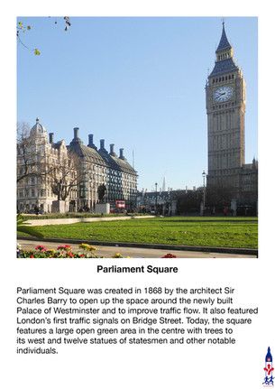
Houses of Parliament - Parliament Square
When King Henry VIII moved to Whitehall Palace after his Palace of Westminster burnt down in 1512, he gave Westminster Hall to Parliament, and the Houses of Parliament was born. The Houses of Parliament was again destroyed by fire in 1834, caused by the ill-advised burning of two large cartloads of wooden tally sticks (a form of medieval tax receipt). It was rebuilt to its current design by Sir Charles Barry and Augustus Pugin and finally completed in 1868.
Parliament Square and St Margaret’s Church
When King Henry VIII moved to Whitehall Palace after his Palace of Westminster burnt down in 1512, he gave Westminster Hall to Parliament, and the Houses of Parliament was born. The Houses of Parliament was again destroyed by fire in 1834, caused by the ill-advised burning of two large cartloads of wooden tally sticks (a form of medieval tax receipt). It was rebuilt to its current design by Sir Charles Barry and Augustus Pugin and finally completed in 1868.
Benedictine monks founded St Margaret’s Church in the 12th century and rebuilt it in the 15th and 18th centuries. This is the parish church for the members of the Houses of Parliament, as the monks did not want them in the Abbey. Notable features include the east window, made in 1509 of Flemish stained glass and created to commemorate the betrothal of Catherine of Aragon to Henry VIII.
Westminster Abbey and the Sanctuary
Benedictine monks first came to this site in the middle of the 10th century and established a tradition of daily worship that continues to this day.
Westminster Abbey, also known as The Collegiate Church of St Peter, has been the coronation church since 1066 and is the final resting place of seventeen monarchs. The present building, begun by Henry III in 1245, is one of the most important Gothic buildings in the country.
The Supreme Court
The Supreme Court is the final court of appeal in the UK for civil and criminal cases from England, Wales and Northern Ireland. It hears cases of the greatest public or constitutional importance affecting the population. It is an independent institution presided over by twelve independently appointed judges, known as Justices of the Supreme Court. The court is housed in the refurbished Middlesex Guildhall on London’s Parliament Square.
Around Whitehall
Guards Memorial and Horse Guards Parade
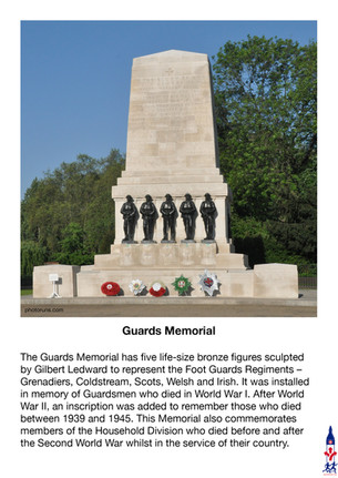
The Guards Memorial has five life-size bronze figures sculpted by Gilbert Ledward to represent the Foot Guards Regiments – Grenadiers, Coldstream, Scots, Welsh and Irish. It was installed in memory of Guardsmen who died in World War I. After World War II, an inscription was added to remember those who died between 1939 and 1945. This Memorial also commemorates members of the Household Division who died before and after the Second World War whilst in the service of their country.
The most prominent building on Horse Guards Parade is the Old Admiralty Buildings, which was built in the late 19th century to accommodate the additional offices needed in the naval arms race with the German Empire. It is a red brick building with white stone, designed in the Queen Anne style. The Foreign and Commonwealth Office and The Department for Education currently use it. At its far end, the fortified Admiralty Citadel was constructed during World War II and had foundations 9 metres deep and a reinforced concrete roof 6 metres thick.
Trafalgar Square
Trafalgar Square is considered the centre of London and is London’s most famous square for celebrations and political demonstrations. This square was designed by Charles Barry and completed in 1845 on the site of the King’s Mews. The square became known as Trafalgar Square to commemorate Nelson’s victory over the French and Spanish in 1805 at the Battle of Trafalgar during the Napoleonic Wars. A Christmas tree has been donated to the square by Norway since 1947 and is erected for twelve days before and after Christmas Day.
Nelson’s Column
This commemorates Lord Nelson’s (Viscount Horatio Nelson) victory at the Battle of Trafalgar in 1812. The 44-metre-high column was erected in 1843. The bronze reliefs at the bottom were made from cannons captured during the battle. William Railton designed Nelson's Column. The statue of Nelson was by E. H. Baily, and Edwin Landseer added the bronze lions in 1867.
King Charles Island – The Centre of London
The statue of King Charles I by the French sculptor Hubert Le Sueur was initially located here in 1633, but after the Parliamentary victory in the English Civil War, the statue was sold for scrap, but instead, it was buried for safekeeping. King Charles I was beheaded in 1649 outside Banqueting Hall in Whitehall. After the Restoration, the statue was recovered and placed in its current location in 1675. Those who signed the Kings execution notice were later executed here. A plaque on King Charles Island indicates that this is also the official centre of London.
Around Leicester Square
Leicester Square
The Leicester Square Statues are famous film stars immortalised in bronze in and around the square. The current collection from 2020 includes Charlie Chaplin, Laurel and Hardy, Bugs Bunny, Paddington Bear, Gene Kelly, Mary Poppins, Mr Bean and Harry Potter. The statue of William Shakespeare is by Giovanni Fontana, an Italian sculptor, and it has formed the centrepiece of Leicester Square Gardens in London since 1874.
Piccadilly Circus
The bright sign for Coca-Cola has been here the longest (since 1955), but the first products were advertised in neon lights here in 1908. Bovril and Perrier were among the promotional pioneers. Even corporate might was unable to stop the lights from being switched off during WW2, and since then, they have also been turned off for individuals on two occasions: Firstly for the funeral of Winston Churchill in 1965, then again for Diana, Princess of Wales in 1997
This video gives you a short introduction to how the Central London Sightseeing area grew during the Tudors (1560) and the Victorians (1860)
6:30 mins
This is a brief overview of the history of the entertainment district in the West End of London.
This video gives you a short introduction to how the West End Shopping area grew during the Tudors (1560) and the Victorians (1860)


Comments