Part 12 - Oxford Circus to Baker Street via Regent's Park - (3.1 Km) - Across London Visual Marathon
- philip carey

- Jan 27, 2023
- 2 min read
Updated: May 28, 2024
Start at Oxford Circus Station
Finish at Baker Street Station

THE EXPERIENCE
A stroll in Regency Park from the BBC
This route takes you from the busy shopping streets around Oxford Circus, up past the BBC and the stunning Regency architecture of Portland Place into the beautifully landscaped Regent’s Park with its delightful gardens, peaceful ponds and fabulous walks. The route finishes at the top end of Marylebone by Baker Street Station, with the Sherlock Holmes Museum, Madam Tussauds and Marylebone High Street nearby.
Great for history, iconic sights, hotels, museums, parks and gardens, boating lakes, and a few places to eat, drink and be merry.

MUST SEE PLACES

What to See List
1 Oxford Street
2 The BBC and Langham’s – Portland Place
3 Harley Street
4 Marylebone High Street
5 Great Portland Street
6 Regent’s Park – The Broad Walk
7 Regent’s Park – Queen Mary’s Garden
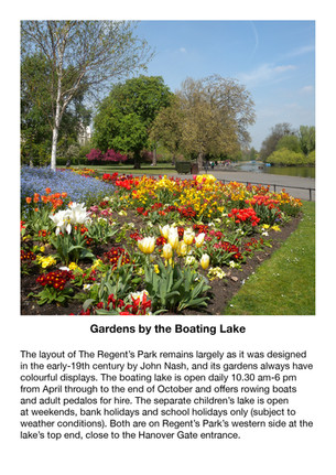
8 Regent’s Park - Boating Lake
9 The Sherlock Holmes Museum – 221b Baker Street
10 Baker Street Shopping
11 Madame Tussauds London
Areas to Eat, Drink and Be Merry
There are only a few places to eat and drink along this route, and these can be found at the start between Oxford Circus and Portland Place, with Regent's Park's Inner Circle, and around Baker Street Station.
BEST TIME
Morning—This is not a busy route. The best time is early morning when the lighting is at its best and few people are around.
Day - This route can get busier during the day, especially at the start and finish.
Evenings - Quieter in most places,
ROUTE OVERVIEW
This 3.1 Km route takes you from Oxford Circus to Baker Street through the south side of Regent's Park. From Oxford Circus Station, it heads north up Regents Street past the BBC’s Broadcasting House, The Langham Hotel and Portland Place before entering the southeast entrance into Regent's Park on Marylebone Road. The route takes you on a floral tour around the Royal Park’s Avenue Gardens and Queen Mary Gardens before exiting by Baker Street Station and the Sherlock Holmes Museum on the western side.
These links open in a new page
DESCRIPTIVE PHOTO GALLERY
This gallery provides a descriptive and visual reference to many sights along this route. Use the Google Map above to find their location. Double-click to see the image in full size.


HISTORY & INTERESTING FACTS
Oxford Circus to Portland Place
Oxford Circus is roughly in the middle of Oxford Street. It was called a circus because it was a turning circle for horses and carriages when it was built in 1819. The tube station, with its red ox blood tiling, dates back to about 1900 and is one of the busiest crossing points in London, with 40,000 pedestrians per hour exploring Oxford Street and Regent Street shops.
Oxford Street
The road was originally part of the Via Trinobantina, a Roman road between Essex and Hampshire via London. In the Middle Ages, it was known as Tyburn Road, which was notorious for public hangings of prisoners at Tyburn Gallows by Marble Arch. It became known as Oxford Road and then Oxford Street in the 18th century. It began to change from residential to commercial and retail, attracting street traders, confidence tricksters and prostitution. Department stores began to dominate the streetscape in the early 20th century, the most imposing of all being Selfridges (which opened in 1909). The street suffered heavy bombing during World War II, and several longstanding stores, including John Lewis & Partners, were completely destroyed and rebuilt from scratch.
The Langham
John Giles designed the Langham, which was completed in 1865 and opened by the Prince of Wales – the future King Edward VII. At the time, it was the city’s largest and most modern hotel, featuring a hundred water closets, thirty-six bathrooms and the first hydraulic lifts in England. Its clients have included Mark Twain, Napoleon III, Oscar Wilde, Sibelius, Diana, Princess of Wales, Winston Churchill and Charles de Gaulle. With a five-star classification, the reconfigured Langham now has 380 rooms and a restored Palm Court that has served afternoon tea since 1865
The BBC
This is the BBC, or more accurately, its headquarters, located in Broadcasting House in Portland Place. It is just up from Oxford Circus on Regent Street and was built in 1932 in an Art Deco style. It has over 22 radio stations.
The BBC, which started broadcasting in 1932, is the world's oldest broadcaster. It has over 22,000 employees and a royal charter. Since it is publicly funded, it has to be impartial and free of adverts.
All Souls Church in Langham Place is the only surviving building of John Nash's original design of Regent Street, constructed in 1824. Today, the church is well known for its musical tradition.
Marylebone Road
Marylebone Road ran east-west from the Euston Road at Regent's Park to the A40 Westway at Paddington, effectively London's first bypass.
Construction of the New Road, as it was called, began in 1756 along the northern edge, and in 1857, the road was renamed Marylebone Road. Marylebone Road was built specifically so that cattle drovers could bypass the busy central streets. Drovers were men who drove cattle and other livestock from the corners of the kingdom into Smithfield Market in the City of London. After surviving for centuries, the railways finally killed off the trade. Today, this very busy road has three lanes in both directions. It is part of the London Inner Ring Road and forms part of the boundary of the zone within which the London congestion charge applies.
Around Regents Park
History of Regent's Park
In 1811, the Prince Regent (the future George IV) set his heart on a new summer palace with its own exclusive grounds in the area we now know as Regent’s Park. The celebrated architect, John Nash, created this bold landscaping design featuring a vast, rounded park surrounded by highly desirable Regency residential villas and a processional road linking this new palace with the prince’s other home, St. James’s Palace. He also designed a stunning summer palace for the Prince Regent which was never built.
At first, the only people allowed in the park were the exclusive residents themselves, and the fashionable 'carriage set' who took part in weekly carriage rides. But in 1835, the east side of the park opened to the public.
In 1838, The Royal Botanic Society laid out the Inner Circle with lawns and a lake, now the site of the world-famous rose collection in Queen Mary's Gardens.
The Regent’s Park is also home to the world’s oldest scientific zoo, the London Zoo, and the oldest outdoor theatre in the world.
Great Portland Street Station
Great Portland Street Station was part of the world's first underground railway, the Metropolitan Railway, which opened between Paddington Station and Farringdon Station. It was opened in 1863 as "Portland Road", renamed "Great Portland Street and Regents Park" in 1923 and then reverted to its present name in 1933. The current structure was built in 1930 on a traffic island on Marylebone Road at its intersection with Great Portland Street and Albany Street. Great Portland Street, was once known as "Motor Row", and was a primary street for cars and related accessories in the early years of the 20th century. The station was originally designed to include a car showroom.
Avenue Gardens
The Avenue Gardens is located on the southeastern side of Regent’s Park and has formal displays of spring bulbs and summer bedding that create a fantastic show. There are tiered fountains, evergreen hedges and vast ornamental bowls filled with flowers. In the centre of the Avenue Gardens stands a large circular stone bowl installed by Newfield in 1863 and supported by four-winged stone lions and is known as the Griffin or the Lion Vase.
Regent’s Park Open Ait Theatre
The Regent’s Park Open Air Theatre was established in 1932 and is one of the largest theatres in London, with a capacity of 1,240 seats), and it is situated on the western side of Regent’s Park. In the last ten years, productions at the Open Air Theatre have won seven Olivier Awards, three Evening Standard Awards and six WhatsOnStage Awards. In 2022, the theatre celebrated its 90th anniversary season.
The Holme
The Holme mansion is located on the Inner Circle in Regent’s Park and was built in 1818. Decimus Burton designed it as a residence for the Burton family and was once described as ‘one of the most desirable private homes in London’
The Holme was the second villa to be built in Regent’s Park, with two storeys above ground and offices in a basement. It was later used by Bedford College and is now a private residence.
The Regent's Bar & Kitchen is located in the middle of Regent's Park on the Inner Circle, close to the Open Air Theatre and the Queen Mary's Gardens western en-trance. It is open seven days a week serving freshly prepared sandwiches and salads, wood-fired oven cooked pizzas, a daily selection of cakes from the bak-ery and hot and cold drinks. There is also a take-away option to enjoy your food in the picturesque surround-ings of the park.
Herons in Regent’s Park
Grey herons, (recognisable with their long legs, long neck, and sharp beaks), can be spotted roosting in trees, sitting by the shallow water, or soaring above the Boating Lake in Regent’s Park. Herons have been visiting Regent’s Park since the early 1930s, with the first pair recorded as breeding in 1968 on what is now called Heron Island. Today, more than 40 herons live in The Regent’s Park. The lake provides them with a natural diet of invertebrates, amphibians and small fish, and their favourite nesting tree is the Horse Chestnut.
221b Baker Street - Sherlock Homes Museum
The Sherlock Holmes Museum is a privately run museum dedicated to the famous fictional detective Sherlock Holmes, as well as Dr Watson and their landlady Mrs Hudson. It opened in 1990 and is situated on Baker Street, bearing the number 221B, although it lies between numbers 237 and 241. It is one of the few properties where there is a commemorative blue plaque dedicated to a fictional character.
The property was built in 1815 and was formerly used as a boarding house from 1860 to 1936.
History Coming soon
VIRTUAL TOUR OF THE AREA
Click on the picture below to go on a 360 virtual tour of the shopping areas and look around.

Use the route to explore this location by looking around in 360, taking in the sights and sounds, listening to an audio recording about the area and going on a virtual tour.


Comments