Part 13 - Baker Street to Marble Arch - (3 km) - Across London Visual Marathon
- philip carey

- Jan 26, 2023
- 2 min read
Updated: May 28, 2024
Start at Baker Street Station
Finish at Marble Arch Street Station

THE EXPERIENCE
A London Village Just North of Oxford Street
This pleasant route from Baker Street to Marble Arch shows you two different sides of London. The journey down Marylebone High Street with its village feel offers a calm contrast to the roaring traffic to its north and the frenetic shopping along Oxford Street to its south. Marylebone offers an agreeable mix of shops and places to eat and drink, as well as Victorian architecture, museums, and places of culture. Wigmore Street also offers a lovely contrast to Oxford Street with its wide, quiet historic streets and impressive buildings. The final part takes you along the western side of Oxford Street with its famous departmental stores and heads towards Marble Arch and Hyde Park.
Great for history, iconic sights, squares, shops, hotels, museums, private clubs, parks and gardens, churches and plenty of places to eat, drink and be merry.

MUST SEE PLACES

What to See List
1 The Sherlock Holmes Museum – 221b Baker Street
2 Madame Tussauds London
3 Marylebone High Street
4 The Wallace Collection – Manchester Square
5 Wigmore Street and Cavendish Square
6 Hanover Square and Regent Street
7 St Christopher Place
8 New Bond Street
9 Grosvenor Square - Mayfair
10 Selfridges on Oxford Street
11 Marble Arch
12 Hyde Park and Speaker’s Corner
Areas to Eat, Drink and Be Merry
Although there are a few places to eat and drink along this route, there are more in the nearby streets. The main centres are Marylebone High Street, Marylebone Lane and around St Christopher's Place. Other areas are near Baker Street, North Audley Street and Portman Square.
BEST TIME
Morning —This will be busy along Marylebone High Street and Oxford Street. The best time is early morning when the lighting is at its best and few people are around.
Day - This route will get busier during the day
Evenings - Generally quieter in most places but fairly busy on Marylebone High Street and Oxford Street.
ROUTE OVERVIEW
This 3 km route takes you from Baker Street Station and heads east along Marylebone Road past Madame Tussauds before turning down Marylebone High Street with its many shops, cafes, and village feel. The route detours into Manchester Square, past the Wallace Collection and then travels east along the wide thoroughfare of Wigmore Street and Cavendish Square before turning south to emerge onto Oxford Street close to Bond Street Station. The final part continues down Oxford Street, dodging the crowds whilst passing Selfridges, Marks and Spencer and Primark before finishing by Marble Arch and close to the sight of the historic Tyburn Gallows.
These links open in a new page
DESCRIPTIVE PHOTO GALLERY
This gallery provides a descriptive and visual reference to many sights along this route. Use the Google Map above to find their location. Double-click to see the image in full size.


HISTORY & INTERESTING FACTS
Marylebone High Street and the Wallace Collection
Marylebone High Street
Marylebone High Street runs between Oxford Street and Baker Street stations and is full of shops and places to eat and drink. Given its secluded location, the street has been described as “the hidden wonder of the West End”. As a result, Marylebone Village, as it is sometimes called, retains a decidedly charming small-town feel, despite its proximity to bustling Oxford Street. Because of this, it has been home to famous residents, including Paul McCartney, Jimi Hendrix and Charles Dickens.
Hertford House - The Wallace Collection
The Wallace Collection is located at Hertford House in Manchester Square, the former townhouse of the Seymour family, Marquesses of Hertford. It was established in 1897 from the private collection mainly created by Richard Seymour-Conway, 4th Marquess of Hertford, who left both it and the house to his illegitimate son Sir Richard Wallace, whose widow Julie Amelie Charlotte Castelnau bequeathed the entire collection to the nation. The collection is arranged into 25 galleries, it is open to the public, and entry is free.
Around Wigmore Street
Madonna and Child - Dean’s Mews
This is a cobbled mews that sits between two grand linked buildings. A very impressive sculpture of the Madonna and Child hangs above the entrance, overlooking Cavendish Square. It was created in 1952 by Jacob Epstein in recognition of the Convent of the Holy Child of Jesus, which formally occupied the Dean’s Mews buildings from 1889. Although the mews are original, all of the buildings date from later redevelopment and post-war rebuilding works.
Wigmore Hall
Wigmore Hall at 36 Wigmore Street is a concert hall that was designed by Thomas Edward Collcutt and opened in 1901 as the Bechstein Hall. The Bechstein Hall was C. Bechstein Pianofortefabrik, the German piano manufacturer, whose showroom was next door. Due to its great acoustics, it specialises in performances of chamber music, early music, vocal music and song recitals. Today, the hall is also a venue for broadcasting and recording. The BBC Radio 3 transmits its lunchtime concert from Wigmore Hall every Monday from September to July.
Cavendish Square
Cavendish Square is just north and west of Oxford Circus behind John Lewis and is at the eastern end of Wigmore Street. Construction started here in 1717 for the 2nd Earl of Oxford by architect John Prince, and was the first development on the Earl's London estate. It was named after the Earl's wife Henrietta Cavendish-Holles. Today it is a public garden square and has a double-helix underground commercial car park, and often has artwork in the garden square.
St Peter – Vere Street
St Peter is and Anglican Church in Vere Street, and was known until 1832 as the Oxford Chapel after its founder Edward Harley, 2nd Earl of Oxford. It sits on the junction with Chapel Place just north of Oxford Street at the side of the old Debenhams building. The chapel was designed by James Gibbs in 1722 and was acquired by the Crown from the Portland Estate in 1817 and was dedicated to St Peter in 1832.
Saint Christopher’s Place
You can arrive at Saint Christopher’s Place through a small Harry Potter-type alleyway called Gee’s Court opposite Bond Street Station on Oxford Street. You emerge in a quaint square filled with colourful shops, bars and restaurants. It is an oasis of calm and a different experience from the crowds and tourist shops on Oxford Street.
Around Oxford Street
Oxford Circus is roughly in the middle of Oxford Street. When it was built in 1819, it was called a circus because it was a turning circle for horses and carriages. The tube station, with its red ox blood tiling, dates back to about 1900 and is one of the busiest crossing points in London, with 40,000 pedestrians per hour exploring Oxford Street and Regent Street shops.
Oxford Street
The road was originally part of the Via Trinobantina, a Roman road between Essex and Hampshire via London. In the Middle Ages, it was known as Tyburn Road, which was notorious for public hangings of prisoners at Tyburn Gallows by Marble Arch. It became known as Oxford Road and then Oxford Street in the 18th century. It began to change from residential to commercial and retail, attracting street traders, confidence tricksters and prostitution. Department stores began to dominate the streetscape in the early 20th century, the most imposing of all being Selfridges (which opened in 1909). The street suffered heavy bombing during World War II, and several longstanding stores, including John Lewis & Partners, were completely destroyed and rebuilt from scratch.
Selfridges
Henry Gordon Selfridge set up his store at 400 Oxford Street in 1909. He was an innovative American who wanted to make shopping fun and adventurous and not a chore. He created a shopping experience and fabulous window displays that quickly became a social and cultural landmark, especially for women. The main entrance to this high-end department store has a sculpture above the door called the Queen of Time, which was put there in 1928.
Primark - Oxford Street West
Primark has two large stores on Oxford Street. The biggest is at the other end of Oxford Street by Tottenham Court Road station, and this one is in New Hereford House, which is close to Marble Arch. Primark is an Irish multinational fast-fashion retailer known for its everyday affordability and fashion styles to suit all generations.
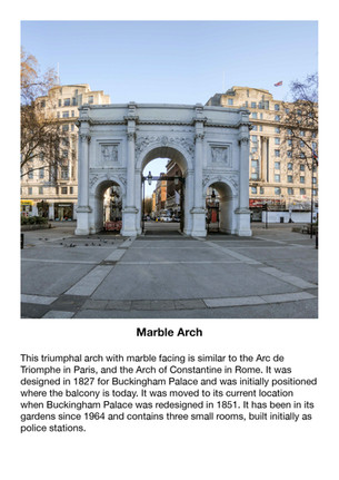
Marble Arch
This triumphal arch with marble facing is similar to the Arc de Triomphe in Paris, and the Arch of Constantine in Rome. It was designed in 1827 for Buckingham Palace and was initially positioned where the palace balcony is today. It was moved to its current location when Buckingham Palace was redesigned in 1851. It has been in its gardens since 1964 and con-tains three small rooms, built initially as police stations.
North Audley Street runs from Oxford Street by Selfridges to Grosvenor Square and is today lined with shops, restaurants, bars and a pub – (there used to be four)
Originally, North Audley Street was built as housing in the 1720s. However, by the 1790s, most of the occupants were tradesmen. These included greengrocers, a butcher, a baker, a saddler, a carpenter and a coal dealer, among others. If you look at the pavement, there are several ‘roundels’ which depict the trades that used to reside here.
This video gives you a short introduction to how the Central London shopping area grew during the Tudors (1560) and the Victorians (1860)
7:26 mins
VIRTUAL TOUR OF THE AREA
Click on the picture below to go on a 360 virtual tour of the shopping areas and look around.

Use the route to explore this location by looking around in 360, taking in the sights and sounds, listening to an audio recording about the area and going on a virtual tour.


Comments