Part 8 - St Paul's Cathedral to Covent Garden (4 km) - Across London Visual Marathon
- philip carey

- Jan 26, 2023
- 2 min read
Updated: May 28, 2024
Start at St Paul's Station
Finish at Covent Garden Station

THE EXPERIENCE
Crossing the Divide - From inside the Old City Walls to the New Central London.
This exciting route takes you on a discovery tour of all the places that link the City of London to Central London. It contains many of the City of London’s historic institutions and icons, such as St Paul’s Cathedral, the Old Bailey Law Court, Spitalfields Meat Market, St Bartholomew’s Hospital, the Museum of London, High Holborn London Universities, and the Inns of Courts. It is rich in history, architecture, interesting streets, and stories to keep you motivated along the way.
Great for history and iconic sights, cityscapes, markets, museums, law courts, inns of courts, universities, culture, theatres, cathedrals and churches. It also has many eating and drinking spots along the way.

MUST SEE PLACES

What to See List
1 St Paul’s and One New Change (shopping)
2 The Old Baily Courts
3 Smithfield's and St Barts Hospital
4 Clerkenwell and Farringdon
5 Hatton Gardens
6 The Inns of Court
7 The Aldwych, LSE and Law Courts
8 Somerset House
9 Holborn and Lincoln's Inn
10 Covent Garden
Areas to Eat, Drink and Be Merry
There are plenty of places to eat and drink along this route. These include the area southeast of St Paul's Cathedral, all around Spitalfields Market, Farringdon and Clerkenwell, High Holborn, Fleet Street, the Aldwych, the Kingsway and Covent Garden.
BEST TIME
Morning—This route will be fairly quiet except at the start and end. The best time to do it is on weekends in the early morning when the lighting is at its best, and few people are around.
Day - This route will be fairly quiet except at the start and end of the routes.
Evenings - Quieter in most places, except around Covent Garden.
ROUTE OVERVIEW
This 4.0 Km section of the Across London Visual Marathon takes you from St Paul's Cathedral, heading north towards the Old Bailey Criminal Court, St Bartholomeus Hospital, Smithfield’s Meat Market, and then past Farringdon and into High Holborn before heading through the Inns of Court, Fleet Street, the Aldwych, and finally Covent Garden via the Kingsway Freemason’s Hall.
These links open on a new page.
DESCRIPTIVE PHOTO GALLERY
This gallery provides a descriptive and visual reference to many sights along this route. Use the Google Map above to find their location. Double-click to see the image in full size.


HISTORY & INTERESTING FACTS
St Paul's to Smithfields
St Paul’s Cathedral
A church has been on this site since AD 604, and it sits on Ludgate Hill at the highest point in the City of London. The current building was designed by Sir Christopher Wren and completed in 1710 (after the old one was burnt down in 1666). Its iconic dome is 364 feet high and is one of the largest cathedral domes in the world. Until 1963, it was the tallest building in London and the second-largest church building in the UK.
Paternoster Square
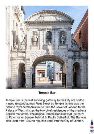
The area takes its name from Paternoster Row, which was once the centre of London’s publishing trade. On 29th December 1940, the buildings on Paternoster Row were destroyed by the Blitz bombings, but St Paul’s Cathedral remained largely intact. The square was developed in 1956 and again in 2003. It is now the location of the London Stock Exchange, which relocated there from Threadneedle Street in 2004. The central column serves as a ventilation shaft. Temple Bar is the last surviving gateway to the City of London. It used to stand across Fleet Street by Temple as this was the historic royal ceremonial route from the Tower of London to the Palace of Westminster, the two chief residences of the medieval English monarchs. The original Temple Bar is now at the entry to Paternoster Square, behind St Paul's Cathedral. The Bar was also used from 1293 to regulate trade into the City of London.
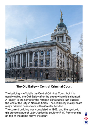
The Old Bailey – Central Criminal Court
The building is officially the Central Criminal Court, but it is usually called the Old Bailey after the street where it is situated. A ‘bailey’ is the name for the rampart constructed just outside the wall of the City in Norman times. The Old Bailey mainly hears major criminal cases from within Greater London.
The current building was completed in 1902, and the symbolic gilt bronze statue of Lady Justice by sculptor F. W. Pomeroy sits on top of the dome above the court.
St Bartholomew’s Hospital
St Bartholomew's Hospital, commonly known as Barts, is a teaching hospital located in the City of London and currently run by Barts Health NHS Trust. It has provided continuous patient care on the same site for longer than any other hospital in England. It was founded by the Priory of St Bartholomew in 1123, and following the dissolution of the monasteries, Henry VIII granted the hospital to the City of London in 1546. In 2023, the hospital will celebrate its 900th anniversary.
Smithfield Market
The Smithfield site has been a livestock market for over 800 years, and it is the largest wholesale meat market in the UK. It is officially known as London Central Markets and has state-of-the-art facilities for receiving, storing, and despatching meat and poultry. It is usually open Monday through Friday from Midnight to 7 a.m. Historically, this site was the market’s slaughterhouse and was occasionally used for some executions.
The Charterhouse
The Charterhouse is a former Carthusian monastery between Barbican and Smithfield Market on Charterhouse Square. Since the dissolution of the monasteries in the 16th century, the site has served as a private mansion, a boys’ school, and an alms-house, which is still in operation today. Residents of the alms-house are known as ‘Brothers’, a traditional term acknowledging the Charterhouse’s monastic past.
High Holborn to the Kingsway
Staples Inn
Staples Inn was once the wool staple, where wool was weighed and taxed. In the 1400s, it became the home of the Society of Staple Inn, an association of lawyers and legal students. They built the great hall and this Tudor-style building in the 1580s. It survived the Great Fire of London but was extensively damaged by a flying bomb in 1944. Staple Inn has been home to the Institute and Faculty of Actuaries since 1887.
Lincoln’s Inn Fields
Lincoln's Inn Fields is a public park with lawns, trees, tennis courts and a bandstand. It was created in the 1630s, and its layout dates from the early 19th century.
As fashionable Londoners moved west, Lincoln's Inn Fields became the home of wealthy lawyers attracted by its proximity to the Inns of Court. Lincoln's Inn Fields takes its name from the adjacent Honourable Society of Lincoln's Inn, one of the four Inns of Court in London.
Kings College The Maughan Library - Chancery Lane
This neo-Gothic building was built in 1851 and was originally the headquarters of the Public Record Office. It was acquired by Kings College University in 2001 and was made into the university library with a dodecagonal reading room inspired by that of the British Museum. Its former medieval chapel is now an exhibition space showcasing the library's special collections. The library was named in honour of Sir Deryck Maughan, an alumnus (graduate) of the university. It is not open to the public.
The Kingsway
The Kingsway was built in 1905 as part of a redevelopment of the area and was opened by King Edward VII, hence the name. The route cleared away the maze of small streets and slums in Holborn and Aldwych and provided the area with better traffic management and impressive architecture along its length, with buildings such as Africa House and Bush House. It still has a vehicle underpass from Waterloo Bridge and used to have a tramway tunnel that went to the Embankment.
Royal Court of Justice
The Royal Courts of Justice, designed by George Edmond Street in the Victorian Gothic Revival style, was opened by Queen Victoria in 1882. The court's previous home was Westminster Hall by the Houses of Parliament. It is one of the largest courts in Europe and is the High Court and Court of Appeal for Civil cases in England and Wales. There are around 20 courts just off the main hall.
Somerset House
In 1552, the Duke of Somerset was executed, and his house became the property of the King, young Edward VI, so the building is still technically a royal palace. The current Somerset House was begun in 1776 and extended in the mid-1800s. This was London's first purpose-built government building containing stamps, tax and navy offices. Today, it's the home of cultural innovators who connect creativity and the arts with the broader society.
St Clement Danes Church
St Clement Danes Church is situated outside the Royal Courts of Justice on the Strand. The first church on the site was founded in the 9th century by the Danes, who settled in the area and took over a small church dedicated to St Clement – the patron saint of mariners. The current building was completed in 1682 by Sir Christopher Wren but was damaged in the Blitz but not restored until 1958 when it was adapted to serve as the central church of the Royal Air Force.
This video gives you a short introduction to how the City of London grew during the Tudors (1560) and the Victorians (1860)
7:26 mins
VIRTUAL TOUR OF THE AREA
Click on the picture below to go on a 360 virtual tour of the shopping areas and have a look around.

Use the route to explore this location by looking around in 360, taking in the sights and sounds, listening to an audio recording about the area and going on a virtual tour.


Comments