Part 4 - Canary Wharf to Limehouse Basin Marina 2.5 Km - Across London Visual Marathon
- philip carey

- Aug 25, 2022
- 2 min read
Updated: May 28, 2024
Start at Canary Wharf Station - eastern entrance.
Finish at Limehouse DLR Station

THE EXPERIENCE
Travelling away from Canary Wharf towards the Limehouse Marina and its canal network
This 2.5 Km section of the Across London Visual Marathon takes you through the heart of the financial district in Canary Wharf along Middle Dock with its modern buildings and then along the riverside at Westferry before finishing off with the calm waters and canal networks within Limehouse Basin Marina.
Good for cityscapes, skyscrapers, river and dock views, parks, marinas, history, icon sights, boat and train access and shopping. It is mainly off-road, with several places to eat and drink at the start and in the shopping areas.

MUST SEE PLACES

What to See List
1 South Dock Views
2 South Quay Footbridge
3 Jubilee Park
4 Middle Dock Views
5 Canary Wharf Plaza and Views
6 Cabot Square and Shopping Centre
7 Museum of London Docklands and North Dock
8 Westferry Circus
9 Thames Path Riverside Views
10 Ropemaker Park
11 Limehouse Marina
Areas to Eat, Drink and Be Merry
The main areas for eating and drinking on this route are within Canary Wharf, at the start of this route. These can be found in Canary Wharf Plaza (5), Middle Dock (4), Cabot Square and Shopping Centre (6), around North Dock (7) and on the riverside at Westferry (8).
BEST TIME
Morning - This is usually busy within Canary Wharf but quiet along the rest of the route. The best time to do it is on weekends in the early morning when the lighting is at its best and there are not many people around..
Day - Most of this route will be fairly quiet. However, Canary Wharf will be busier.
Evenings - Quiet in most places except in the main centres of Canary Wharf.
ROUTE OVERVIEW
This 2.5 km route starts outside Canary Wharf Station. It goes through the tranquillity of Jubilee Place Park to emerge in Canary Wharf Plaza with spectacular cityscapes and views along Middle Dock. It follows the northern shore before heading off to Cabot Square and then down to Westferry Circus and the river Thames. The route then hugs the Thames Path until it crosses Limekilm Dock Bridge to emerge onto Narrow Street. It heads a short way west before diverting into Ropemakers Park and then into Limehouse Marina, where it follows the dock shoreline until it reaches Limehouse DLR Station.
These links open in a new tab.
DESCRIPTIVE PHOTO GALLERY
This gallery provides a descriptive and visual reference to many sights along this route. Use the Google Map above to find their location. Double-click to see the image in full size.


HISTORY & INTERESTING FACTS
Canary Wharf
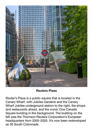
The centre of Canary Wharf is located by West India Middle Dock and Reuters Plaza.
Canary Wharf is best known for its tallest building, the 235-metre One Canada Square. The tower was the tallest structure in the United Kingdom from 1990 (when it overtook Tower 42 in the City of London) until 2010 (when The Shard surpassed it in south London).
Canary Wharf also has 300 shops, cafes, bars and restaurants, a year-round events programme, one of London’s biggest roof gardens and an award-winning, free-to-visit public art collection.
West India Docks
The West India Docks are a series of three docks, quaysides, and warehouses built on the Isle of Dogs in London to import goods from and export goods and occasionally passengers to the British West Indies. The first of these opened in 1802.
The docks were constructed in two phases. The two northern docks were constructed between 1800 and 1802.
The southern dock, the Southwest India Dock, later known as South Dock, was constructed in the 1860s to replace the unprofitable City Canal.
Following their commercial closure in 1980, the Canary Wharf development was built around the wet docks by narrowing some of their broadest tracts.
The Museum of London Docklands is nearby and explains the history of the River Thames, the growth of the Port of London and the dock’s historical link to the Atlantic slave trade.
Canary Riverside
Canary Riverside is a popular spot for relaxed dining, riverside strolling, and enjoying spectacular views across London.
You can catch the Uber Boat from Canary Wharf to central London or Woolwich and take the smaller boat across the river to Nelson Dock Pier at the Hilton Hotel in Rotherhithe.
Rotherhithe has a long history as a port, with many shipyards from Elizabethan times until the early 20th century and with working docks until the 1970s.
Limehouse and Limehouse Basin
Limehouse
Limehouse relates to the local lime kilns or, more precisely, lime oasts by the river and operated by the large potteries that served shipping in the London Docks.
Limehouse became a significant port in late medieval times, with extensive docks and wharves.
Limehouse Basin
Limehouse Basin was built in 1820 as a navigable link between the River Thames and the new Regent's Canal
Limehouse Basin is the gateway between the River Thames and over 2,000 miles of navigable canals and rivers. and it includes the Limehouse Cut - the oldest canal in London and one you may recognise from a certain Mission Impossible film sequence.
Once a dock, Limehouse Basin is today a marina, home to narrowboats, yachts, and visiting ocean-going pleasure craft. With shops and cafes, it still makes for a great spot for a family day out or afternoon stroll.
The Commercial Railway (later the London and Blackwall Railway) opened Limehouse Station in 1840 under the name Stepney. At that time, the Commercial Railway had a separate station named Limehouse, one stop to the east.
VIRTUAL TOUR OF THE AREA
Click on the picture below to go on a 360 virtual tour of the shopping areas and have a look around.

Use the route to explore this location by looking around in 360, taking in the sights and sounds, listening to an audio recording about the area and going on a virtual tour.


Comments