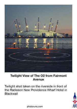
Part 3 - East India DLR to Canary Wharf Station - 2.5 Km - Across London Visual Marathon
- philip carey

- Feb 19, 2022
- 2 min read
Updated: May 18, 2024
Start at East India DLR Station
Finish at Canary Wharf Station - eastern entrance

THE EXPERIENCE
A trip towards the Canary Wharf skyline from the east
Discover Canary Wharf's emerging scenic ‘cityscape’ as this 2.5 Km section of the Across London Visual Marathon route unfolds. It will take you from East India DLR, through Blackwall and then into tranquil Poplar Dock Marina. It then flows into Blackwall Basin with its cityscape reflections and through the eastern entrance into Canary Wharf. From there, it explores the east side of Canary Wharf near Canada Square and South Dock before finishing at Canary Wharf underground station by Jubilee Park Gardens.
It is great for cityscapes, historic dock views, fish markets, skyscrapers, and the occasional large superyacht. Towards the end of the route, there are also a few food and drink options.

MUST SEE PLACES

What to See List
1 Poplar Docks
2 Blackwall Basin
3 Billingsgate Market
4 Coldharbour
5 Blue Bridge Lock Views
6 Harbour Quay
7 Crossrail Place
8 Jubilee Park
9 South Dock Views
10 Millwall Dock
11 South Quay Footbridge
12 Underground Shopping Centre
Areas to Eat, Drink and Be Merry
The main areas for eating and drinking on this route are within Canary Wharf, at the end of this route. The Canary Wharf Shopping Centre (12) has plenty of places to grab a quick bite and indulge yourself amongst its three floors of shops. There are places with dockside views in Harbour Quay, Reuters Plaza, and on the south side of South Dock.
BEST TIME
Morning -This is usually a quiet route but can be busier within Canary Wharf. The best time to do it is on weekends in the early morning when the lighting is at its best, and there are few people around.
Day - Most of this route will be fairly quiet. However, Canary Wharf will be busier.
Evenings - Quiet in most places except in the main centres of Canary Wharf.
ROUTE OVERVIEW
This 2.5 km route starts outside East India DLR station on Blackwall Way and makes its way towards Blackwall. This part of the route is not very scenic at the start, but it soon takes you to the tranquil setting of Poplar Dock, which has many nearby places to explore by the river. This route takes you around Poplar Dock Marina and then into Blackwall Basin with views towards the cityscapes of Canary Wharf. It enters via Trafalgar Way with Billingsgate Fish Market on the right and then makes its way towards South Dock (one of the three docks that make up West India Dock). It follows this west for a short distance before heading up into Upper Bank Street by Canary Wharf Station and Jubilee Place.
These links open in a new tab.
DESCRIPTIVE PHOTO GALLERY
This gallery provides a descriptive and visual reference to many sights along this route. Use the Google Map above to find their location. Double-click to see the image in full size.


HISTORY & INTERESTING FACTS
Billingsgate market and the Traffic Light Tree
Billingsgate Market is one of London's oldest markets, dating back to the 10th century. Originally located in the City of London, it was moved to its current site near Canary Wharf in 1982.
Today, Billingsgate is the United Kingdom's largest inland fish market. Its merchants sell an average of 25,000 tonnes of fish and fish products each year. While Billingsgate is primarily a wholesale market, it's also open to the public. However, public access is limited to specific hours (usually from 4 a.m. to 8 a.m.), and visitors can purchase seafood at wholesale prices.
Traffic Light Tree – Billingsgate Market
It was created by the French sculptor Pierre Vivant and is 8 metres tall and contains 75 sets of lights. The pattern of the lights is said to reveal and reflect the never-ending rhythm of the surrounding domestic, financial and commercial activities.
South Dock
South Dock was originally called the South West India Dock and was constructed in the 1860s, replacing the unprofitable City Canal, built in 1805.
The Docks' design allowed a ship arriving from the West Indies to unload in the northern dock, sail around to the southern dock and load up with export cargo in a fraction of the time it had previously taken in the heavily congested and dangerous upper reaches of the Thames.
Today, the South Dock still has visits from some sizeable ships.
Canary Wharf
Developed on the site of the former West India Docks, Canary Wharf contains around 1,500,000 m2 of office and retail space. It comprises many open areas, including Canada Square, Cabot Square and Westferry Circus. Together with Heron Quays and Wood Wharf, it forms the Canary Wharf Estate, around 97 acres in area.
Around 105,000 people work in Canary Wharf and it is the European headquarters of numerous major banks, professional services firms, and media organisations, including Barclays, Citigroup, Clifford Chance, Credit Suisse, EY,, HSBC, JPMorgan Chase, KPMG, and Thomson Reuters.
Before its transformation into a financial hub, Canary Wharf was primarily an industrial area with docks and warehouses. The decline of the London docks in the 1960s and 1970s led to its redevelopment.
In addition to its role as a financial center, Canary Wharf is also a popular destination for shopping and dining. It boasts several shopping malls, including Cabot Place and Canary Wharf Shopping Centre, offering a wide range of shops, restaurants, and cafes.
Canary Wharf hosts various cultural events and exhibitions throughout the year. This includes art installations, music concerts, food festivals, and outdoor film screenings, making it a lively and dynamic area beyond just business
As of 2023, Canary Wharf has five out of the top ten tallest buildings in the United Kingdom.
One Canada Square and Landmark Pinnacle are the third and fourth tallest buildings in the United Kingdom.[13]
The 75-storey Landmark Pinnacle is the tallest residential tower in the United Kingdom and the whole of western Europey.
West India Dock
West India Docks were constructed in two phases. The two northern docks were constructed between 1800 and 1802
The southern dock, the South West India Dock, later known as South Dock, was constructed in the 1860s,
The Docks' design allowed a ship arriving from the West Indies to unload in the northern dock, sail around to the southern dock and load up with export cargo in a fraction of the time it had previously taken in the heavily congested and dangerous upper reaches of the Thames. Around the Import Dock, a continuous line of five-storey warehouses was constructed, designed by architect George Gwilt and his son, also named George. The Export Dock needed fewer buildings as cargo was loaded upon arrival. To protect against theft, the whole complex was surrounded by a brick wall 20 ft (6.1 m) high.
VIRTUAL TOUR OF THE AREA
Click on the picture below to go on a 360 virtual tour of the shopping areas and have a look around.

Use the route to explore this location by looking around in 360, taking in the sights and sounds, listening to an audio recording about the area and going on a virtual tour.


Comments